


A NASA Spacecraft Shared A Photo Of Dawn On Mars
3- 7.10.2026, 13:35
- 4,752
The panorama was captured by the Mastcam on August 11.
A recently released panorama captured by NASA’s Curiosity rover is the most detailed image yet of distant, wind-eroded Martian rocks, revealing features that the mission’s scientists have long wanted to examine up close.
The image was taken at 8:30 a.m. local Martian time; impressive blue hues are visible in the foreground, and the bright morning light illuminates rock formations known as yardangs on the horizon, according to New Voice.
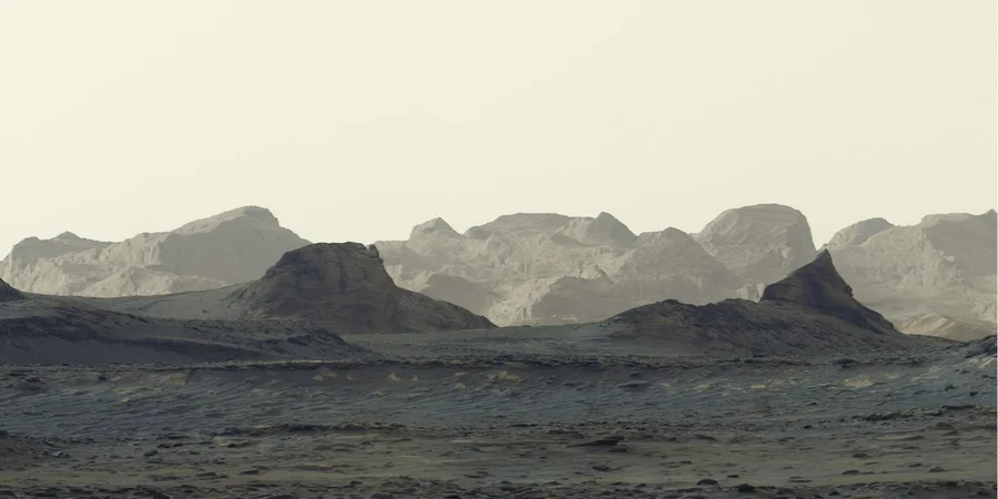
The panorama was captured by the Curiosity rover’s Mastcam on August 11—the mission’s 4,982nd Martian day (or sol)—and consists of six separate images stitched together after being transmitted to Earth. Unlike most images taken by the Mastcam, this frame was processed without white balance correction, preserving the characteristic morning lighting.
The Yardang Belt stretches approximately 16 kilometers along the northwestern slopes of Mount Sharp—a 5-kilometer-high peak that Curiosity has been climbing since 2014. Moreover, the rover recently passed a major milestone in its ascent, reaching an altitude of 1 kilometer—a record for the highest elevation ever reached on Mars. As it approaches the yardangs, mission scientists expect to capture even more impressive images and, they hope, find answers to the question of how these rock formations were created.
Mount Sharp consists of layers, each of which reflects a distinct period in Mars’ history. By studying them, scientists have been able to learn more about the lakes and streams that covered this part of the Red Planet billions of years ago. Eventually, the water evaporated, leaving behind salt minerals. After the accumulation of new material on the mountain ceased, some of it was likely weathered away, leading to the formation of yardangs.
“The yardang layer looks out of place. It has an unusual color, the layers are tilted at a strange angle, and it looks as if it were pasted on,” said Ashwin Vasavada, the Curiosity project’s principal investigator at NASA’s Jet Propulsion Laboratory in Southern California. “But that’s exactly what makes it accessible for study. No one knows for sure how this layer formed, but one hypothesis suggests it could be ash from ancient volcanic eruptions.”
Curiosity is in the second year of its fifth extended mission, which began with an investigation of box-shaped, latticed ridges. The rover will spend most of the next year (or so) traversing layers rich in sulfates and carbonates—signs of ancient surface drying. Around 2027, scientists hope to reach the base of the yardangs, where Curiosity will be able to use its robotic arm to collect unique data about these mysterious formations.
NV Techno previously reported that the Perseverance rover has been exploring the Red Planet for more than five years, but has now reached a region that the mission team has dubbed the “Wild West.” The rover has ventured far beyond the boundaries of Jezero Crater and set out to explore the ancient Lac de Charmes Plateau.
This area is located west of the crater’s high rim and is replete with deep valleys and rocky ridges. This area contains the oldest igneous rocks the rover has ever encountered in its entire mission.

Bank's name: Bank Millennium S.A.
Address: ul. Stanislawa Zaryna, 2A, 02-593, Warszawa
IBAN: PL97116022020000000216711123
SWIFT: BIGBPLPW
Name of the account holder: Fundacja “KARTA ‘97”
Purpose/title of payment: Donation for statuary aims
You can contact us by the e-mail [email protected]